

Pilotage
The Use of GPS in Pilotage.
The advent of GPS has revolutionised navigating and pilotage in small craft. They give us the ability to know our position and movements very rapidly. However, this apparent ease of use can lead to problems if some care is not taken.
The first and most obvious aspect is that of differing chart datum. GPS uses the WGS 84 datum and whilst newly published charts are often drawn to this datum, older ones are not. In addition to this, the original surveys were done without the use of GPS, in some cases they may have be carried out with a lead line over 100 years ago.
When offshore the slight differences between the chart and GPS datum is normally irrelevant, but when you are close in to rocks, an error of 100m could make a huge difference.
I saw an example of this in Galicia in Northern Spain. One of my crew was a local yachtsman, as we were passing through a very tricky pilotage area and he had local knowledge, he was piloting the boat. As a back up, I had one of the crew below watching the position on the GPS and comparing it to the chart.
As the rocks were surrounded by deep water and there was a small swell, a useful approach was to aim for the breaking waves, then when at an appropriate distance from the rock, turn and pass round it before heading on to the next. There were no buoys or navigation beacons in sight!
We reached a point where our pilot said that the previous year a British yacht had struck a rock and sunk. We could easily see that we were clear of the danger but the navigator below was very nervous because the GPS indicated that we were heading straight on to the rock. In fact the instructions he was giving from watching only the GPS and the chart would have put us on the rock!
I am certain that is what happened to the boat the year before. I think they relied on the electronics and the inaccuracies in the system caused the sinking.
So when using GPS close to the land it is vital that you are aware there may be errors, and to keep a good lookout around you. The basic rule of always back up what you are doing with an independent system of checks always applies.
Even when the GPS is interfaced with a chart plotter, there can be errors. Whilst motoring down the Beaulieu River in thick fog, we had the radar and the chart plotter running. From the radar and the depth of water, we could clearly see that we were in the centre of the channel, whilst the chart plotter put us in the field to one side!
Positions from GPS
One of the challenges with GPS is how to put the indicated position on the chart quickly when you are in confined waters. If you are spending too long at the chart table it is easy to not notice that the vessel is being carried out of the safe water,
There are several approaches:
Bearing and distance from a compass rose
The dot at the centre of the compass rose is entered as a waypoint, if this waypoint is then tracked by the GPS, the vessel's position can be quickly plotted on the chart by laying a straight edge from the centre dot across the correct bearing on the compass rose. The distance off is measured with the dividers and that is the boat's position.
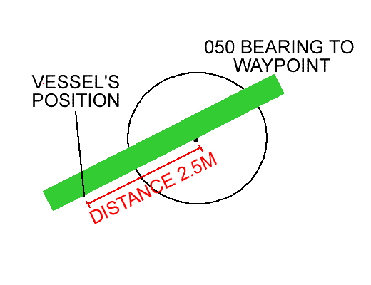
Remember that the bearing is towards the compass rose!
Distance from waypoint and cross track error
If the chart is marked up with the distance to go to each waypoint in 0.5M intervals. The distance to go function combined with the cross track error will give a position that can be quickly placed on the chart.
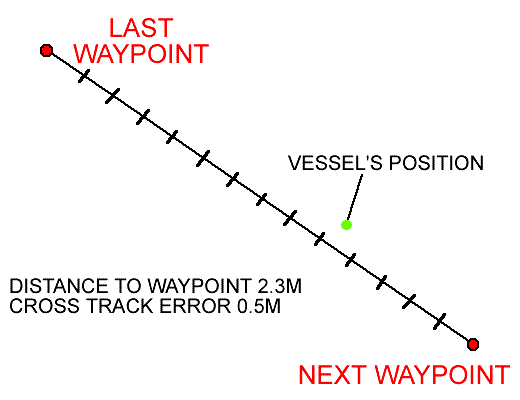
This technique is especially useful when the vessel is travelling at high speed.
Obviously you need to know if you are off track to port or starboard.
Position webs
By drawing a series of bearings at 10 degree intervals from the waypoint, then marking off distances at 0.5M intervals, a web of lines is created. When the distance and bearing to the waypoint is obtained from the GPS, it can quickly be compared to the pre-drawn grid and a position placed on the chart.
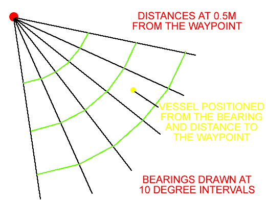
This approach is especially useful when the vessel sails in the area frequently, such as the approaches to a harbour.
Because this can take a considerable amount of time to draw on the chart it may be best to leave the web on the chart. Another approach is to draw the web for the full 360°, then copy it on to a clear acetate sheet. This sheet can then be laid over the chart for ease of use. This works best if you are using charts where the scale is the same, such as with the Admiralty Leisure Chart Folios.
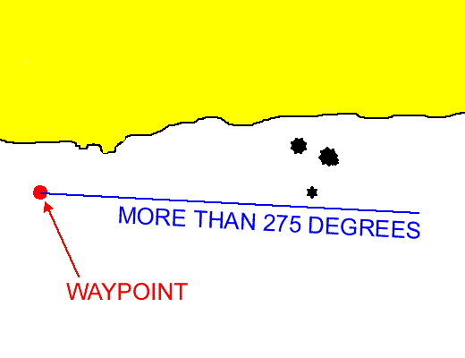
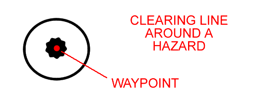
Clearing line from a waypoint.
When there is no easily positioned object to use for a clearing line, a waypoint can be chosen at a suitable point. When this waypoint is monitored, its bearing should remain in the safe sector.
Danger zones
If there is an isolated danger, a waypoint can be placed on the danger. The distance to the waypoint function can be used to ensure that the vessel remains a safe distance from the hazard.
Clearing distances
If there are dangers on either side of a passage, clearing lines can be placed parallel to the route. As long as the cross track error does not exceed this distance the vessel will remain in safe water.
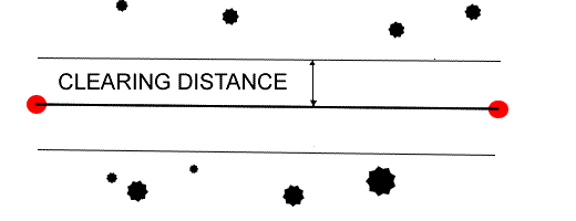
Chart Plotters
A chart plotter, especially one mounted in the cockpit makes pilotage very simple.
One of the aspects to look at when purchasing a chart plotter, whether it is a handheld or a fixed version is the screen refresh speed. A speed that is adequate in open water may be far to slow for pilotage when in confined waters, as the yacht may have passed off the screen by the time it has refreshed to the new position.
You should also ensure that the chart datum is the same as the GPS datum in the set up menu.
It is also important to remember that you should be monitoring where the vessel's track over the ground will take you in the future and not just checking the current position.
Sailtrain.co.uk is free to use, but if you feel you would like to contribute to the running and development costs you can donate via Paypal:
Additional Resources:
