

GPS derived positions
Positions obtained by GPS are so accurate that we really need to look at what we mean by accuracy.
Datum
When a chart is created a model for the shape of the World is used. As the World is not a perfect sphere there are a variety of models or Datums in use.
British Admiralty charts have often used the Datum created by the  Ordnance Survey in 1936. This is listed on the chart in the information under the title. This is often referred to as OS36.
Another datum used on Admiralty charts is European Datum 1950 (ED50). This is used for charts covering the coasts of continental Europe.
There are slight differences in positions from one datum to another, so to be very accurate we need to know the datum of the chart that the position is being referred to. In the past, in practice this did not matter because it was not normally possible to navigate to a sufficient level of accuracy that the difference in the datum caused a problem.
With the advent of GPS this has all changed. GPS units on yachts give a position to three decimal places, this is an apparent accuracy of less than 2m. The datum used for GPS positions is World Geodetic System 1984 (WGS84). Just like OS36 and ED50 this datum uses a model of the World that is slightly different to that used by other datums.
This means that a position derived from GPS should be adjusted to be 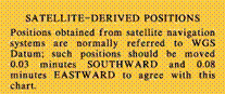 plotted correctly on a chart with another datum. On RYA Training Chart 2 this correction is as shown in the image.
In practice this correction is so small that you may decide to ignore it. However for very fine positioning the correction may make a difference. Some years ago I was correcting a chart for Shoreham Harbour in Sussex, I realised that I was placing port hand beacon on the starboard side of the channel. When I checked the difference was that the chart was in OS36 datum and the correction referred to WGS84 positions.
There are several means of correcting for datum errors.
- The positions derived from GPS can be changed by the amount given on the chart prior to being plotted.
- Many GPS receivers have an offset function that allows the correction to be entered once, then all positions displayed on the screen will be displaced by that amount.
- The simplest method is normally to change the datum that the information is displayed in, in the set-up menu. You will find a selection of datums, you just need to select the one that matches the chart you are using.
Although datum errors are normally small in Europe they can be as large at 700m in some parts of the World.
Survey errors
Even in well visited areas there are charts that were originally surveyed a considerable time ago.
The survey dates are listed on a chart in the source data diagram. In the one on the right, the earliest survey was done in 1872-95, obviously this was done with a leadline and positions would have been found with a compass or sextant.
You can imagine the level of accuracy this work was done to. Even more recent surveys were not done using equipment that is as accurate a that found on any small craft today.
As a result the positions we obtain from GPS are far more accurate that the charts we plot them on to. For this reason, claims of great accuracy should be treated with caution.
Newly published charts are being created to the WGS84 datum, so this problem will slowly go away, but it will take some time to cover the entire World.
Chart errors
In most well frequented areas the charts can be considered to be fairly accurate, however in areas that are rarely visited and then mainly by small craft there can be considerable errors in the charted positions of quite large objects, like islands! In more remote parts of the World a prudent skipper would not rely too closely on the given positions of reefs and small islands.
Whilst in the Rias Bajas region in northern Spain (a great unspoilt cruising ground) a few years ago I was piloting a yacht through an area of rocks, there were very few aids to navigation so the approach was to aim for the breaking water that marked the rocks then turn aside and skirt round them at a safe distance (the rocks you can see are not the dangerous ones!). As a back up I have one of the crew monitoring our position on the GPS, the person with this job was getting very agitated at one point as he was certain we were going to hit a rock that we could quite clearly see the position of. If we had followed his instructions we would have hit it directly.
One of my crew was a local yachtsman and he said that the previous year a British yacht had been sunk on that rock. I believe that they were too reliant on the GPS information and in calm weather there was no white water over the rock to warn them off. The charted position of the rock was only about 50m out but was enough to cause this sinking.
New Charts
New charts are being published that are drawn to the WGS84 datum, with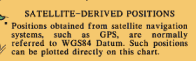 these positions obtained from a GPS receiver can be plotted directly on to the chart.
Sailtrain.co.uk is free to use, but if you feel you would like to contribute to the running and development costs you can donate via Paypal:
Additional Resources:
