

How does GPS work?
What is GPS?
GPS is a satellite navigation system operated by the US military. Although its main purpose is for military use it has been available for some time to be used by any one who can afford about £100 for a basic receiver.
There are at least 24 satellites in operation at any time, early receivers could track only a few at one time but modern sets normally track and obtain information from 12 satellites. This enables the system to be very accurate. The satellites are positioned 11,500 out from the Earth and orbit the World twice a day. This means that the system is available at anytime, to anyone, anywhere in the World.
Each satellite has a very accurate atomic clock aboard, the signal that is transmitted by the satellite includes the time taken from the atomic clock and the position of the satellite, the receiver calculates the time taken for this transmitted signal to arrive and from this can create a position sphere.
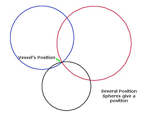
A position sphere is a sphere on which the vessel lies, in the same way that a bearing taken on a charted object gives a position line when plotted on a chart.
To obtain a good position fix the receiver needs to receive the signals from at least 4 satellites, as the receiver lies on the intersection of the position spheres obtained from the satellite it is able to give the vessel's latitude and longitude as well as the vessel's course and speed over the ground.
How accurate is GPS?
The positions given by GPS are far more accurate than those required for normal navigational purposes by yachtsmen.
When the system was first started there was a built in error called Selective Availability, this degraded the accuracy for civilian use by a random error of about 200m, with the development of means a circumventing this error it has become irrelevant and has been discontinued since May 2000.
With Selective Availability removed, GPS positions are accurate to about 15m 95% of the time, of course 5% of the time the errors may be much larger. A prudent navigator would not be relying on electronics to this level of accuracy, long before you are this close to hazards you should be using every means at you disposal to identify your position. This includes; observation, depth readings and common sense.
Differential GPS
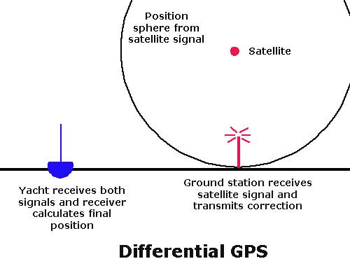
There are slight errors inherent in the system used for GPS signals, one source of these errors is delays in the radio signal caused by atmospheric conditions, as time is so critical to the calculation of a position sphere this can cause errors in the final position given. For most yachtsmen these errors are going to be irrelevant as the level of accuracy obtained is sufficient for our purposes.
The means of making GPS more accurate is for a fixed ground station to receive the signal, as it "knows" its own position it can calculate the local errors. It is then possible to transmit another signal that contains the information required to correct the information given by the satellite. This can result in positions accurate to 3-5 metres.
To use Differential GPS (DGPS) you need to purchase a receiver that has this extra function built in.
WAAS
For some uses normal GPS accuracy is not sufficient. The means to make the signals more accurate over a large area is called Wide Area Augmentation System (WASS).
For aviation, civil engineering and agricultural use, very accurate positions are required. To achieve this a network of receiving stations are required, these stations calculate the errors in the satellite signals, then the corrections are re-transmitted up to two geo stationary satellites over the equator (ones that are fixed over the same spot on the Earth's surface). These satellites then transmit the correction signal over a large area. Anyone with a WASS enabled set can receive these signals which should be accurate to less than 3m.
As the satellites are positioned over the equator the WASS signal can sometimes be obscured in high latitudes by mountains and forest. Although this system works best over open water, it is probably far more accurate than most yachtsmen will require.
GLONASS
There is an equivalent Russian military system in operation GLONASS, Global Navigation Satellite System
Galileo System
The European Union has just launched the first satellite for its own GPS system, Galilleo. This would give Europe complete independence from the US system.
Not very surprisingly, the American military is already discussing means of jamming this system to prevent its use by hostile elements.
GPS and Sat Nav StoreSailtrain.co.uk is free to use, but if you feel you would like to contribute to the running and development costs you can donate via Paypal:
Additional Resources:
