

Quick position plots from GPS.
Although GPS positions are generally very accurate it is not always convenient to plot a latitude and longitude on to a paper chart.
There are some short cuts that have been developed for use in specific situations.
Waypoint on the compass rose
A popular one is to plot a waypoint at the dot in the center of a compass rose. The receiver is then set to track the bearing and distance to the waypoint. The other preparation is to mark the side of a piece of A4 sized paper with the distance scale from the edge of the chart, this gives you a ruler marked in nautical miles.
The advantage of this is that it only takes a moment to lay the edge of the paper across the compass rose from the dot to the bearing round the outside. This indicates the direction. Distance is read off on the scale that has been created.
This means that the distance can be read at the same time as the bearing and a position plotted on the chart in seconds.
Alternatively the side of a plotter or a ruler can be used and distance measured with a pair of dividers.
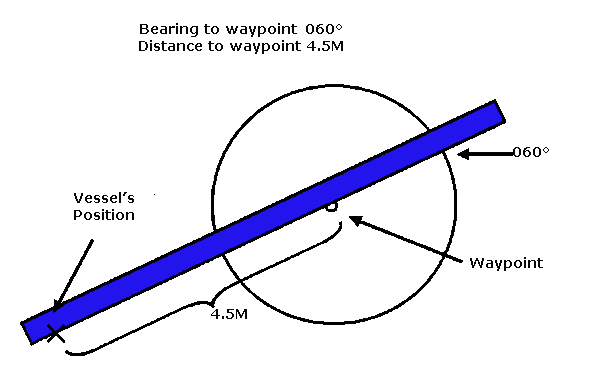
The important point to remember is that the bearing to the waypoint indicated on the GPS receiver is towards the waypoint. In the example above the bearing to the waypoint is 060 and the distance is 4.5M.
This technique is especially useful when working in close to land and absolute accuracy is less important than being able to get a position plotted on the chart quickly. Once this is done the navigator can quickly return to the deck and continue to keep a lookout for any hazards or navigation marks.
3)
On chart 3.
Enter the dot at the center of the compass rose in the north east of the chart as a waypoint.
Plot the bearing to the waypoint on the outer ring of the compass rose.
BEARING TO THE WAYPOINT 342°T
Measure off the distance.
DISTANCE TO WAYPOINT 1.75M
What is the vessel's position?
Distance to go and cross track error (XTE)
If the vessel is travelling from one waypoint to another (typically when following a route) the distance to the waypoint can be marked off on the chart at 0.5M intervals. At any time the the distance from the next waypoint can be quickly placed on the chart.
If there are also lines drawn parallel to the ground track between the two waypoints at 0.5m intervals, the XTE can be used to plot the position of the vessel very rapidly.
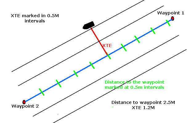
This method is especially useful in high speed craft when there is not time to plot positions conventionally on the chart. As the chart can be prepared with the bearings, distances and cross track error markings before leaving harbour this technique is ideal.
4)
Chart 3.
Enter WPT1 46° 5.53'N 005° 47.30'W
Then enter WPT2 46° 5.90'N 006° 09.55'W
Plot ground track between these two waypoints
Mark off distance to go to WPT2 at 1.0M intervals
Once this is done, plot vessel's position when the XTE is 1.1M to starboard of the ground track and the Distance To Go is 6.5M , find the latitude and longitude.
Position webs
If a series of bearings at 10° intervals are drawn towards a waypoint and the lines marked with the bearings, it is very easy to position the vessel in a triangular section between two bearings. If the distances off are also marked by drawing arcs at 0.5M intervals it is easy to plot the vessel's position between two of these arcs by using the distance to go.
The resulting lines look like a spiders web which is where this technique gets its name.
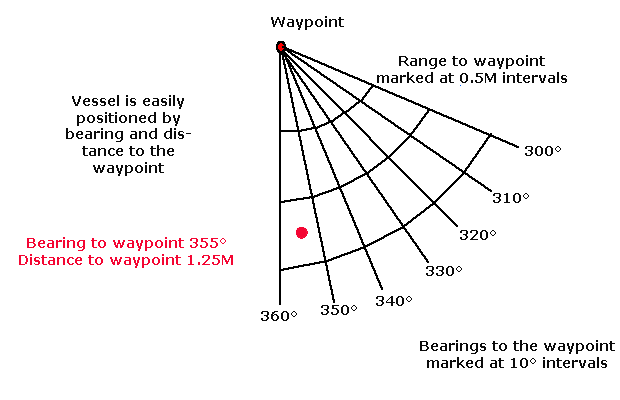
It takes quite a lot of work to create the web, so this is a technique that is best used in an area that you use a lot. The lines can be left on the chart for next time.
An alternative approach is that you could print the web on to a clear plastic sheet then just lay it over the chart when you want to use it. This will only work if you have charts of the same scale, if you use the Admiralty Small Craft packs this is sometimes the case.
5)
Chart 3.
You are entering the channel between Strong Holm and North Douglas Island at night and beating against the wind.
You have a waypoint at the east cardinal buoy (46 ° 14.0'N 005 ° 51.44'W)
Plot bearings towards the buoy at 10 degree intervals from 200 °T to 260°T. Write the bearing by each line.
Mark off arcs at 0.5M intervals from the waypoint. Write the distance to the waypoint by each arc.
A. If the bearing and distance to the waypoint is 238° T 5.3M and the vessel is heading 150° M, what should the skipper do?
GPS and Sat Nav StoreSailtrain.co.uk is free to use, but if you feel you would like to contribute to the running and development costs you can donate via Paypal:
Additional Resources:
