

Navigation and Chart work - Tidal Information on Charts
TIDAL DIAMONDS
Spread around a chart are magenta coloured diamonds, each with a different identifying letter in the middle.

The letter used has no significance, they are labelled in alphabetical order, the letters are then used to identify the correct part of the table printed on the chart.
On Training Chart 2, below the title information there is a table which allows us to calculate the direction and speed of the tidal stream at each of these Tidal Diamonds.
See the extract below:
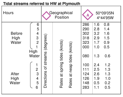
The data in this table is referred to HW at Plymouth! So even though Plymouth does not appear on this chart, we can look up the tidal stream information for this area by knowing the time of high water Plymouth.
On Practice Chart 1, you will find the same thing written above the tidal stream table. So even if you are sailing near St Malo in France, the tidal streams are calculated relative to high water at Plymouth.
We can do this because the tidal streams follow a pattern throughout the whole Channel area, and the tide in one area is directly influenced by what happens elsewhere.
To read this table:
The first column on the left is the key to the rest of the data. Information is given for six hours before and after high water Plymouth at hourly intervals.
The centre column tells us that the three figure numbers in the diamond 'A' column are the direction of the tide in degrees true (measured from north), and the other two sets of numbers are the rates of tide at springs and neaps (we will cover this in more detail later, spring tides run at about twice the speed of neap tides).
The right hand column is the tidal stream information at the given latitude and longitude for each hour before and after high water.
So at Diamond A (South of the entrance to Salcombe Harbour), when it is high water at Plymouth the tide is running in a direction of 080° at a speed of either 1.3 knots or 0.6knots.
Tidal levels
Below the tidal diamonds table there is a table which gives the levels of the tide at certain times at important points on the chart.
MHWS M ean H igh W ater S prings
MHWN M ean H igh W ater N eaps
MLWN M ean L ow W ater N eaps
MLWS M ean L ow W ater S prings
The Mean is the average tide. It is a word used frequently in navigation.
MHWS is the average of the highest high tides,
MHWN is the average of the lower high tides,
MLWN is the average of the higher low tides,
MLWS is the average of the lowest low tides.
The range of the tide is amount is rises or falls between high and low tide.
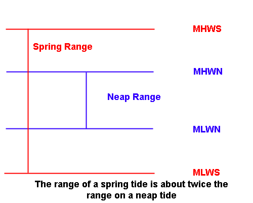
Typically the range of a spring tide is twice that of a neap tide. As the time for the tide to rise or fall between high and low tide does not very much, the rate of the tidal stream is about twice as fast on a spring tide than on a neap.
Additional Resources: