

Navigation and Chart work - Tidal Streams
Tide tables
There are many types of tide tables. The Training Almanac is similar in layout to Reed's Almanac, which is one of the most popular almanacs available in Britain. It is published annually and covers many ports in Europe from Germany to Portugal. A publication of this type is invaluable if you are going to sail any more than a few miles from your homeport. At the other end of the scale, if you only sail locally, you may find a simple tide table available at your local chandlers for 20p is sufficient.
Turn to page 33 in your Training Almanac.
This is the page for Victoria. Always check that you are looking up information for the correct port!
In the top left corner there is a box noting the time zone the tables are correct for. The time zone is UT or Universal Time. As far as we are concerned this is the same as GMT.
Under the time zone is written: For Summer Time add one hour to the non-shaded areas.
During the period of the year when Summer Time is in force, we must add one hour to the times given in the table to bring them in to line with the time we are using.
When you are dealing with tidal information, it is valuable to rewrite the information you will be using, but I suggest that you start by drawing a box around the day in question. This will ensure that if you look away, you will come back to the correct place! (In the real book, cross out each day when it is finished, you will not need the information again).
Many of the problems people encounter during courses are caused by untidy working, get into the habit now of laying your work out in a standard manner and keep it tidy. Remember, when you are skippering a boat, the navigation will be only one of your responsibilities, if you are untidy, you will lose track of what the numbers mean.
We are going to look at May 28th.
May 28 Victoria Summer Time
LW 0609 0.6
HW 1225 5.5
LW 1831 0.8
HW 0043 5.6
5.5m - 0.6m = 4.9m
To decide if this range is a spring or neap tide. Look on the top right corner of page 36. In the mean range box, the figures for a spring tide range is 4.9m and for a neap is 2.4m (these figures only apply to Victoria!).
Therefore this is a spring tide.
It may seem a lot of work to lay this information out like this for each question that you do, but if you can establish a thorough method of working from the beginning you will make fewer clerical errors. Most of the errors in navigation are not caused by a lack of understanding, but by untidy working.
Tidal Streams
For the first navigation questions you are given the tidal stream data. Once you have been introduced to the concepts you will have to work out your own information.
There are two sources of tidal stream data:
Tidal Diamonds
and
Tidal Atlases.
Tidal Atlases
Tidal atlases are used for planning passages, and can be used to find detailed tidal data for navigation.
There are several types of atlas:
Admiralty Tidal Atlas The Hydrographic Office publishes atlases for most British and European waters. They are very easy to use and cover a range of scales, from one that covers just the entrance to Portsmouth Harbour to one that covers the North Sea .
Yachtsmen's Tidal Atlas There are several publishers who sell atlases with yachtsmen in mind, they often have other information that may be of use-such as tidal height calculators and can be very useful.
Almanacs. Most almanacs include tidal stream atlases, they are small and not very detailed, but are adequate for most purposes, and they are all included in the price of the Almanac! We will be using the ones on pages 13-25 in the Training Almanac. Turn to it page 19 now and find the diagram for high water Victoria.
The information is given as an arrow in the direction of the current, the bolder the arrow the stronger the tide. If we want to find the direction of the tide a little more accurately, we can measure the direction of the arrow with our plotter. Just line the grids on the plotter up with the side of the chart.
Find the east going arrow just south of Cape Woodward (46°7.8'N 006°5.5'W), the rates of the tide are given as 12.22. This means that the neap rate is 1.2 knots and the spring rate is 2.2 knots. Remember that the spring rate will be about twice the neap.
If you measure the direction of the arrow with your plotter you will find it is about 096°T.
You will notice that there are diagrams for the period from 6 hours before high water Victoria to 6 hours after. Each diagram represents what the tide does during the period of one hour. To use the atlas we need a time of high water at Victoria.
On May 28th it is 1225 Summer Time and the range is 4.9m, so this is a spring tide.
The diagram for high water covers the average tidal conditions for one hour, from half an hour before, to half an hour after high water. In this case from 1155 to 1255.
In pencil, write these times below the diagram, then on the page for the hour before, write 1055 to 1155, and so on until you have put times to each of the diagrams before and after high water.
If you fill the atlas in like this for each day, it is very easy to see the pattern of the tides. This helps you to plan when to start and end a voyage when you are planning a trip. The period when the tide is in your favour is called a Tidal Gate or Tidal Window. A little time in preparation will make life much easier when you get out on the water.
Use the tidal atlas to answer the following questions.
Question 1.
Between which times would you experience a favorable tide on May 27th, on a passage from Victoria to Dunbarton (46°11.0'N 6° 00.0'W)?
Question 2.
How many miles would the tide carry you in the previous question? Assuming a boat speed of 3Kn.
Tidal Diamonds
Spread around the chart there are points for which tidal data has been collected and tabulated for us to use. These points are indicated by tidal diamonds, a magenta diamond with an identifying letter in the middle.
On Chart 3 the table with the information is at the top. It includes diamonds from A to R, for each there is a latitude and longitude.
Can you find diamond Q on the chart?
Look back at the table. Printed on the top is: Tidal Streams Referred to HW at Victoria.
Diamond Q is near Fitzroy, but we still use HW Victoria for the calculations.
To find the tidal stream at diamond Q, 3 hours before HW - place a ruler under the line of figures and read off the data in the correct section.
180°T 1.1kn or 0.6kn.
Tidal direction information is always given in true because it is never used on a compass, only on the chart. The rates are given in knots, obviously the higher rate is springs.
On chart 3, at diamond B, what is the tidal stream at the following times?
Question 3.
At HW on a spring tide?
Question 4.
3 hours before HW on a neap tide?
Using chart 3, what is the tidal stream at the following times?
Question 5.
Cape Woodward at 0337 summer time on July 14th?
Question 6.
South of Slade Island on January 23rd at 2028 standard time?
Tidal streams in navigation problems
When yo are working out an EP or a course to steer, to be strictly correct, the data should be used for half an hour before to half an hour after the tabulated times, in a similar manner to the tidal atlas.
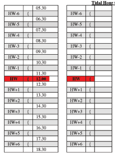
For example, if HW was at 1200 we could use the form to the right to find the correct hour to use for the tidal data.
In this example, if we were on a passage between 1330 and 1430, we would use the information for HW+2.
This may seem a long process, but until you are very familiar with the concept I suggest that you use the layout above to work out which hour relative to high tide that you need data for.
These forms can be downloaded as a PDF file.
Question 7.
East of South Douglas Island on 26th April, between 0044 and 0144 summer time?
Question 8.
Just north of Cape Donne, on 7th April, between 0323 and 0423 summer time?
Non-spring or neap tides
Most tides will not be exactly a spring or neap tide, but will fall between, occasionally you will also experience tides of a greater than spring range or less than a neap range.
In any of these situations we may need to be more accurate with our workings than just accepting the tabulated figures. Follow the example below:
Chart 3. What will be the direction and rate of the tide at Diamond A, at HW+5 hours, if the range of the tide was 3.6m?
From the chart, the spring rate is 2.0kn and the neap 1.0kn.
As a range of 3.6m this tide in not a spring or neap tide, to answer this we need to use the computation of rates diagram, which is found on page 26 of the Training Almanac. These are normally found in Admiralty tidal atlases as well as Reed's Almanac.
To use the diagram: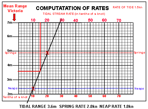
• Mark with a cross the neap and spring tidal rates on the dotted lines which denote the ranges for those tides at that port. Note that the figures along the top and bottom are in tenths of a knot.
• Then draw a sloping line through and past both crosses.
• On the left side, find the range of the tide in question, and draw a line to the right, until it crosses the sloping line.
• From the point where the two lines cross, draw a line up or down to find the rate of the tide for that range.
The tidal rate is 1.5kn for a tidal range of 3.6m.
You could probably have guessed at this figure because the range of the tide was midway between the spring and neap ranges, therefore the rate would also be half way between the spring and neap rates, it is not always that simple.
Let's try again with a real tide.
Question 9.
What is the rate of the tide on September 11th at 0541 summer time at diamond B?
Multiple hour calculations
If we need to find the tidal stream information for a period of longer than one hour we need to ensure we use all the information.
Question 10.
What is the rate of the tide on July 21st between 10.17 and 12.17 summer time at diamond H? As this covers two hours, you will need two completely separate pieces of data for each hour. Do not try to average them out.
For any navigation we would need to use both the pieces of tidal data.
Set and Drift
It is very important that you keep a clear idea of whether you are dealing with a speed or a distance. It is very easy to think they are interchangeable when you are working for 1-hour periods.
If the tidal stream is 2kn, in 1 hour it will travel 2M, but in half an hour only 1M. The distance the tide travels in a period may be referred to as the tidal drift, whilst the direction may be called the tidal set.
Accuracy of tidal stream information
The data from the atlas and tables comes from the same sources, so if you find a place in the atlas where there is a diamond on the chart, you will see that the information is the same. Compare the information for diamond F on Chart 3 (Cape Woodward) with the same place on the tidal atlas.
The way that tidal data is presented leads to the impression that it is very accurate. It is important to remember that the figures given are only averages and may vary considerably from the tides you experience.
The weather may be one cause of inaccuracy. Strong winds may hold the tides back, then when they do run, the rate may exceed the tabulated figure.
A prudent navigator is always assessing the accuracy of the information used. Every time you pass a navigation buoy or a fishing marker, look at the tidal flow and guess for yourself what the rate and direction is. If necessary, alter the figures from the tables to suit what you observe. Always remember that navigation is an art, not a science!
Other methods of determining the tidal stream
One method of measuring the rate of the tide is to stop next to a buoy, keeping it steady alongside your vessel. When you can see that you are not moving relative to the buoy, read the log (gives the boat speed through the water), and you will know the speed of the tide, the direction will be the reciprocal of the boat's heading. This can be useful when fine navigating in fog.
A similar result could be achieved on a calm day by anchoring provided the tide is strong enough.
Some modern GPS systems when interfaced with an electronic chart plotter will calculate the tidal information, from the difference in speed and heading relative to the ground and water.
You can also buy software packages with tidal stream information, but some people may say that is making life too easy!
Additional Resources: