

Navigation and Chart work - Chart Information
Look at Chart 3, Under the title there is some important information that is explained below.
DEPTH IN METRES
These are metric charts. Most charts are now, but you will still find some Imperial ones in use. Imperial charts have depths in fathoms and feet (a fathom is 6 feet, about 2 metres). These charts are easily identified, as they are in black and white, not coloured like the metric ones.
Take care with Stanford's charts of the Caribbean, as on some, the depths are metric and others are in imperial units. Because both types look similar, it is easy to miss the change when you move from one chart to the next.
SCALE 1:100,000 at lat 46°.
Chart scales vary dependent upon the use they will be put to. A vessel should carry a selection of charts, which cover a variety of scales. This should ensure there are large-scale charts for entering harbour and pilotage, medium scale charts for navigating on and small-scale charts, which cover large geographical area for planning passages.
Depths are in metres and reduced to Chart Datum.
Chart Datum is essentially the level below which the tide never falls, allowing for the movements of the Sun, Earth and Moon.
On Admiralty charts, all the blue and white coloured areas are 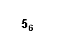 permanently water. The numbers written in these parts are the minimum depths to be found at that point, in metres and decimetres. Normally there will be a greater depth of water as it is unusual for the tide to fall that low. The depth on the right indicates a minimum depth at that point of 5.6m.
These numbers or CHARTED DEPTHS are not the only depth 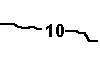 indication. There are also contour lines on the seabed. These join places of equal depth below chart datum. The depth is written within the contour line.
On a contour line, if you can not see a depth indicated, look at the depths on either side of the line and you should be able to deduce the depth at the contour. It will normally be a multiple of 5 or 10m except the 2m contour on some charts.
On chart 4A, find the contour line between the light and dark blue colours and follow this line down the chart. If you look at the depths on either side of the line it is easy to deduce that this is the 5m contour, even if you can not see that depth indicated on the contour itself.
HEIGHTS are in metres. Underlined heights are drying heights above Chart Datum. Vertical clearance heights are above Highest Astronomical Tide. All other heights are above Mean High Water Springs.
The green areas of the chart are sometimes covered and sometimes  not. In these places there are numbers which are DRYING HEIGHTS. On chart 4A, find Outer Rocque Island. Off the southern end of the island there is a drying height of 1.8m indicated.
Chart Datum is the level from which the height of the tide is measured, when you look in a tide table and the height of high water is given as 4.5m, that is 4.5m above Chart Datum.
Drying heights are heights above Chart Datum, in an area with a drying height of 0.5m, the depth of water would be 0.3m if the height of the tide was 0.8m and the bottom would be 0.2m above the water level if the height 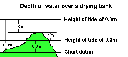 of the tide was 0.3m.
If the height of the tide falls to 0m, the water level would be on the border between the green and blue areas on the chart.
The buff or yellow areas are above Mean High Water Springs and are nearly always uncovered. They may only cover if there is an above average high tide. For most practical purposes we can say that these areas are always land. However in an area of salt marsh, all these areas may be just covered at the highest tides which can make pilotage quite tricky due to the completely different shape of the land.
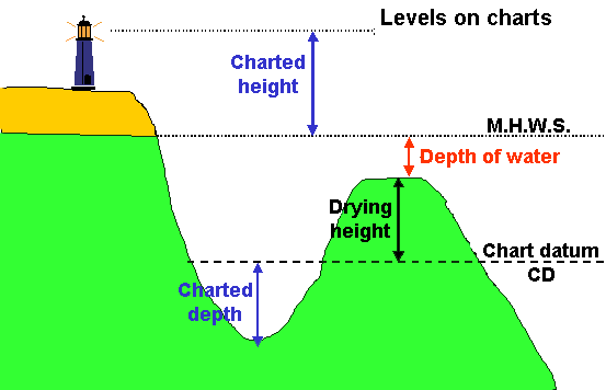
Heights of land feature are called CHARTED HEIGHTS. They are measured above Mean High Water Springs (the average of the highest high tides).
A height above mean high water springs may be indicated by a contour line, by a spot height, that is a number with a dot next to it (In the south east corner of chart 4A, find the 82m spot height ) or on a feature such as a lighthouse by the height being included in the detail of the light, in this situation "m" indicates metres and "M" indicates miles.
S. Steven Point light house (Iso.6s60m24M) on the south west corner of chart 4B, has a height of 60m above mean high water springs and a nominal range of 24 miles.
Where the feature is too small for the height to be written on it, such as a small rock or islet, the height will be written next to the feature but will be enclosed in brackets. On chart 3, see if you can find the rock which stands 16m above mean high water springs just off Cape Gannett in the north west corner Slade Island. There are a couple of other similar islets near by.
Heights above H.A.T.
In some parts of the World the height of objects such as bridges or cables that cross waterways are given above Highest Astronomical Tide (HAT). These are normally area with small tidal ranges such as the Baltic or Mediterranean.
On chart 3 and 4, below the title there is a reference to this. It states, "Vertical clearance heights are above Highest Astronomical Tide." Whilst this is unusual in UK waters, you will encounter this in other parts of the World, so the rule is, always read the text below the titles of charts when you move to an unfamiliar area!
In the south east corner of chart 4C, find the bridge over the river leading to Blackmill Marina.  On the land to the east of the bridge there is a symbol that indicated the height of the bridge over the datum level in use for this chart. In this case it is 15m above H.A.T. On most charts this would be 15m above M.H.W.S.
Positions are referred to WGS84 Datum. (See SATELLITE-DERIVED POSITIONS note).
When the curves of the Earth's surface are converted to a flat sheet, map 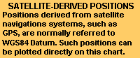 makers have a model of the shape of the world, which affects the way the chart appears. Different organisations use different models for the shape of the Earth.
On charts 3 and 4 this is the WGS84 (World Geodetic System 1984) datum. This means that if you are using a GPS navigator you can transfer positions obtained from the GPS to the chart with no adjustments. Provided your GPS receiver has not been adjusted to display positions in a different datum.
Other datum in use are OS36 (Ordnance Survey 1936) and ED50 (European Datum 1950). On older UK charts you may find the datum is one of these. As new charts are being issued the datum is being updated to WGS84.
In the past the datum in use was not important in small craft navigation, as the differences were very small compared to the level of accuracy of navigation. However, Global Position System (GPS) navigators give a position to 3 decimal places, around Britain this is a theoretical accuracy of about 2 metres. This is obviously ridiculously accurate as the charts were not surveyed to this level of accuracy, and in practice the system should probably only be relied on for an accuracy of 100 metres. Certainly once you are this close to hazards you need to be looking for them rather than relying on the electronics!
Because GPS uses a datum called WGS 84 (World Geodetic System 1984) for a model of the world, where is a built in error when converting GPS positions to positions on a chart using OS 36 datum.
On these charts, there is a special warning about the use of satellite derived positions on this chart. As you can see there is no correction required. However, you should always check to see which datum has been used, and what the error is, because in some places the error may be significant. In practice, the correction may be so small that it can be ignored in a small vessel.
To be strictly accurate, GPS positions should be corrected by the amounts given. To avoid this you may find in the set up menu of your GPS receiver that you can change the datum to match that of the chart you are using.
Navigation marks: IALA Maritime Buoyage System - Region A (Red to port): Region B (Red to starboard) in the Neptune Islands.
This tells you the buoyage system in use in the area covered by the chart. There are two systems, A and B, system B buoyage mainly being used in all of the Americas and Caribbean. Go to the section on buoyage to find out more.
As these charts have been created for training use anywhere in the World both systems of buoyage have been included on one chart. In practice this is unlikely to occur.
Sources: The origin, scale, date and limits of the hydrographic information used to compile the chart are shown in the Source Diagram. Depths in upright figures are from older surveys.
Different areas of the chart will have been surveyed at different times. In remote areas the survey may have been over 100 years ago and done with a lead line and sextant! If the bottom is mainly rock it may not have changed much in the intervening years but somewhere like the Thames Estuary, with its shifting sand and mud banks will change after every winter storm.
On chart 3, the source diagram is in the north east corner. What is the oldest data on this chart?
Additional Resources: