

Navigation and Chart work - Fixes
Fixes
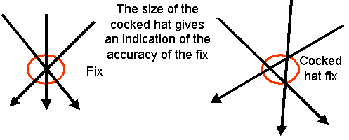
When a fix is made up from only 2 position lines the disadvantage is that if  there is an error, you have no way of knowing. However, if you plot three position lines, when there is an error it will show up, because the lines will cross in a triangle. This is known as Cocked hat, the size of the cocked hat giving an indication of the level of accuracy of that fix.
Whilst it is possible that the vessel could be inside the cocked hat, it may also be outside of it. Most navigators assume they are in the center of the triangle provided it is not too large and there are no hazards near by.
If your fix results in a large cocked hat, it is probably better to try again, perhaps by using different features.
 The standard symbol for a fix is to draw a circle around the area and write fix next to it. You should also record the time and the log reading when you take the bearings. This information is normally written next to the fix on the chart.
We have a standard way of working of the chart, so that if there are several navigators, they all use the same system, then you will not be woken up in the middle of the night because someone does not understand your chartwork.
When you plot a fix using a handbearing compass, it is not 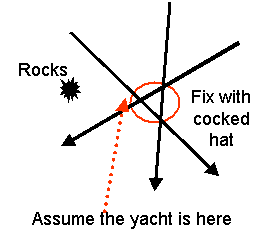 certain that you are at that spot. A prudent skipper would assume they are in that area, and if there were any hazards, would consider the vessel to be near to them.
Sometimes buoys are used to take the bearings, however, it is better to use land-based objects; these are less likely to move than a buoy. If there is nothing else that you can see, buoys can be used with caution.
Something to remember when you plot a fix is that it is where you were when you took the bearings-you will have moved since then!
If you recorded the time and the log reading at the time of taking the bearings, you will be able to deduce where you are now, and more importantly whether where you are going is safe. Remember that at 6 knots a vessel will have covered one mile if you take 10 minutes to plot the fix.
A useful back up piece of information when you take a fix is the depth of water. If, after allowing for the height of the tide, the depth recorded and the charted depth do not agree, the fix should be treated with caution. However, if they agree, it tends to confirm the accuracy.
This kind of thinking is how you should run your vessel, especially when navigating there are no definite answers when we are out on the water. In the classroom we should strive for pinpoint accuracy in our working, but out on the sea there may be many unknown variables for the skipper to allow for.
Questions
Chart 3. Variation = 7 °W. Plot the following fixes. Give your answer as a latitude and longitude.
1.
Radio Mast (46° 19.53'N 006° 12.87'W) = 039°M
End of Cape Woodward (46° 08.73'N 006° 03.48'W = 121°M
St Anthony Head Lt Ho (46° 13.88'N 006° 10.11'W) = 091°M
Answer.2.
Back Shoal Beacon (46° 21.38'N 005° 51.18'W) = 157°M
Hill Shoal Beacon (46° 20.45'N 005° 55.06'W) = 210°M
Flagstaff (46° 24.42'N 005° 57.08'W) = 289°M
3.
Radio Mast (45° 44.75'N 005° 45.11'W) = 211°M
Beauty Point Lt (45° 47.04' 005° 46.61'W) = 270°M
Pentire Island Lt (45° 44.96'N 005° 40.73'W) = 147°M
4.
Church Spire (46° 25.79'N 005° 58.45'W) = 320°M
East side of Kay Island (46° 21.86'N 005°55.70'W) = 202°M
Light on Southlake Pt (46° 23.58'N 005° 59.27'W) = 276°M
Additional Resources: