

Navigation and Chart work - Secondary Port Calculations
Secondary ports
All the ports that we have dealt with up to now have been standard ports-that is ones for which tidal data is tabulated. However, most of the ports you visit will be secondary ports, at these ports you must calculate your own times and heights of high and low tide.
Most Standard Ports will have a collection of Secondary Ports for which the tide heights and times are calculated from the information in the tide table for the Standard Port.
Very roughly, there is a standard difference in the time of high and low 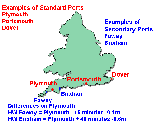 water between the Standard and Secondary Port, if we know this difference we just add or subtract it to the time at the Standard Port to find the time for the Secondary. The heights are dealt with in the same way.
On the diagram to the right you can see that Fowey and Brixham are secondary ports of Plymouth.
If the tide table tells us that HW Plymouth is 12.00 4.5m, the HW information for Fowey is 11.45 4.4m and Brixham 12.45 3.9m.
Some times the tidal differences can be quite large even over a small distance. In the Solent the spring range at Portsmouth is 3.9m and at the west end of the Solent only about 2.0m. That is why it it is important to allow for the differences between ports, they may be larger than you expect.
This above is a very simplistic approach to applying the differences between Standard and Secondary Ports and for a Dayskipper student is probably adequate in most situations. The table we use for looking up the differences is in the Almanac.
Find page 37 in theTraining Almanac.
This is for Bramhope Creek. At the top of the page it says Standard Port VICTORIA, and there is an arrow indicating in which direction to look in the almanac to find the Standard Port.
The times section is divided in to high and low water. The first two columns are the approximate time of high water on a spring tide and then on a neap (this is not always the case, sometimes they will be reversed).
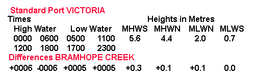
All the information at the bottom of this table is the differences to the times and heights of high and low water at Victoria to find the information for Bramhope Creek.
Looking at the heights first, if the height of high water is close to 5.6m at Victoria it will be 0.3m higher at Bramhope Creek, if the height is close to 4.4m the difference will only be 0.1m higher. The low waters are dealt with in the same manner.
On the time side of the table, if high water is close to 0000 the next one will also be close to 1200 so the difference to apply is +0006 minutes, however if hgh water is close to 0600 and 1800 we will subtract -0006 minutes to find the time of high water at Bramhope Creek. In this case the low water difference is always +0005 minutes.
Follow this example for 11th August.
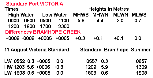
Note that we have left the times in UT until the last step when the summer time is added. This is because the differences are based on the standard time at the Standard Port. Standard time at Victoria is UT (Universal Time).
Although this is a long process, I suggest that you write down each stage as you go along. If you do not, it is very easy to lose track of what you are trying to achieve. This is especially important when you think that this is only one step of a larger calculation. Most of the errors with tidal hight questions are from untidy working rather than understanding of the principles.
We will now do the same thing for Dawson Harbour (page 86 of the Training Almanac) on 9th October.
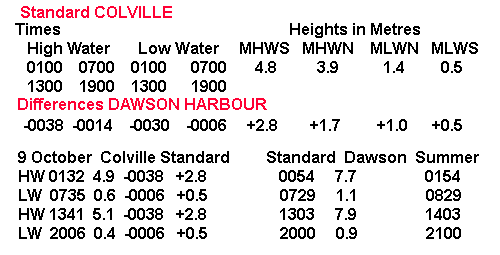
Because the real times of high and low tide at Victoria do not match the ones given in the table, I have selected the nearest one when deciding which difference to use. Although this is not strictly accurate if the tide on the day in question is not a spring or a neap tide; it is accurate enough for our purposes.
Non spring or neap tides
In the previous examples the tides have been conveniently close to spring or neap tides. Provided the actual heights and times are close to those on the differences table this is normally close enough for practical use.
You will find sometimes that the date does not fit quite so tidily. There are very accurate mathematical methods of working out what the exact difference should be but you should not be spending a great deal of time doing these calculations. If possible you should learn to estimate the differences by eye rather than spending 20 minutes getting a mathmatically exact answer that may be on 10 or 20cm different to a quick estimate.
The following example is not a neat spring or neap tide.
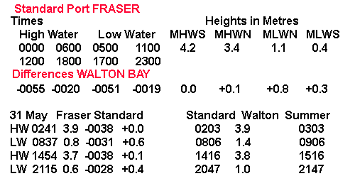
Looking at the HW heights, 3.9m there is only a choice of between 0.0 and +0.1, I have chosen 0.0 because the height of HW at Port Fraser is closer to 4.2m than 3.4m.
3.7m is closer to 3.4m the level for MHWN at Port Fraser so the difference is +0.1.
For the low waters, the level of 0.8m at Port Fraser is a little closer to the MLWN than half way between the given figures of 0.4m and 1.1m, so I estimated the difference as being +0.6m. The other low water of 0.6m is close to the MLWS figure so the difference is +0.4m.
With the times, a high water at Port Fraser of 0241 is about mid way between the tabulated times of 0000 and 0600 so the difference is going to be about midway between -0055 and -0020 minutes, or -0038 minutes.
I used a slightly different approach for the LW heights.
The difference between 0500 and 1100 is 6 hours, over these 6 hours the difference at Walton Bay changes from -0019 to -0051 minutes or 32 minutes, approximately 5 minutes for each hour that the time of LW has changed at Port Fraser. The low water of 0837 is about 2.5 hours earlier than 1100 so the difference has changed by 2.5 X 5 minutes or 12.5 minutes.
As 0837 is closest to 1100, this correction is applied to the difference of -0019, giving a difference of about -0031 minutes.
Using the same approach the difference for a LW of -0028 minutes.
Question 1.
What are the times in Summer Time and heights of HW and LW at Itchenham (page 52) on 10th June?
Question 2.
What are the times in Summer Time, and heights of HW and LW at Walton Bay (page 62) on 17th August?
Using Secondary Port information
Once you have calculated the times and heights of the tide for a Secondary Port this information can be used in the same way as the original data to make calculations. The data for the secondary port is used on the curve for the standard port, the only difference is that you need to decide if the tide is a spring tide or a neap tide based on the range of the tide at the Standard Port, this is because the range at the Secondary Port will be different once the corrections have been applied.
Using the information from the previous 2 questions, work out the following.
Question 3.
What is the height of the tide at 1502 Summer time at Itchenham on 10th June?
Question 4.
When will the tide rise to 3.2m at Walton Bay on the afternoon of August 17th?
You will need to work the following question out from the beginning.
Question 5.
If a boat with a draught of 1.5m anchors outside Endal Marina(page 64) at 1422 Summer Time on 21st September.
A) What will be the height of the tide at 1422?
B) What will be the fall of the tide between 1422 and LW?
C) What will be the minimum depth in which to anchor at 1422 if a clearance of 1.5m is required at LW?
Question 6.
What are the times in Summer Time and heights of HW and LW at Port Rampton (page 60) on September 26th?
Additional Resources: