

Navigation and Chart work - Rising and Dipping Lights
Rising and dipping lights
Because of the curve of the Earth's surface, the light of major navigation marks (light houses and ships) will be out of sight even though the light may be powerful enough to reach as far a vessel. The distance you can see a major light is influenced by the height of the light and the height of eye of the observer as well as the power of the light itself.
When your height of eye is too low, but the light is powerful enough to 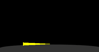 reach as far as your position you will see a loom of light, which is
the beam of the lighthouse shining in an arc as it crosses the sky. If it is a really dark moonless night, lights can be seen at a considerable range, it is even possible to take a bearing on the light in these conditions. On one cross channel passage I was able to take a fix from lights that were 50M away on the French and English coasts.
reach as far as your position you will see a loom of light, which is
the beam of the lighthouse shining in an arc as it crosses the sky. If it is a really dark moonless night, lights can be seen at a considerable range, it is even possible to take a bearing on the light in these conditions. On one cross channel passage I was able to take a fix from lights that were 50M away on the French and English coasts.
This effect will continue, until suddenly the light appears over the horizon. At this point, it is very simple to calculate the distance from the light, using a table in the almanac. As the curve of the Earth is reasonably constant, nautical almanacs contain a Rising and Dipping light table which easily gives the distance off from a major light.
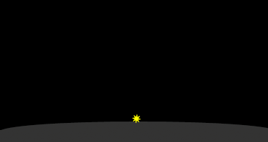
We can take the bearing, so to plot a position on the chart all we do is plot the bearing, then measure off the distance from the light, that is the vessel's position!
Look inside the back cover of the Training Almanac (copy below). The table is one we use to calculate our distance off from a light when it just appears (or disappears) over the horizon.
Height of light |
Height of Eye |
|||||||||||
metres |
feet |
metres | 1
|
2
|
3
|
4
|
5
|
6
|
7
|
8
|
9
|
10
|
| feet | 3
|
7
|
10
|
13
|
16
|
20
|
23
|
26
|
30
|
33
|
||
|
|
||||||||||||
10 |
33 |
8.7 |
9.5 |
10.2 |
10.8 |
11.3 |
11.7 |
12.1 |
12.5 |
12.8 |
13.2 |
|
12 |
39 |
9.3 |
10.1 |
10.8 |
11.4 |
11.9 |
12.3 |
12.7 |
13.1 |
13.4 |
13.8 |
|
14 |
46 |
9.9 |
10.7 |
11.4 |
12.0 |
12.5 |
12.9 |
13.3 |
13.7 |
14.0 |
14.4 |
|
16 |
53 |
10.4 |
11.2 |
11.9 |
12.5 |
13.0 |
13.4 |
13.8 |
14.2 |
14.5 |
14.9 |
|
18 |
59 |
10.9 |
11.7 |
12.4 |
13.0 |
13.5 |
13.9 |
14.3 |
14.7 |
15.0 |
15.4 |
|
| |
||||||||||||
20 |
66 |
11.4 |
12.2 |
12.9 |
13.5 |
14.0 |
14.4 |
14.8 |
15.2 |
15.5 |
15.9 |
|
22 |
72 |
11.9 |
12.7 |
13.4 |
14.0 |
14.5 |
14.9 |
15.3 |
15.7 |
16.0 |
16.4 |
|
24 |
79 |
12.3 |
13.1 |
13.8 |
14.4 |
14.9 |
15.3 |
15.7 |
16.1 |
16.4 |
17.0 |
|
26 |
85 |
12.7 |
13.5 |
14.2 |
14.8 |
15.3 |
15.7 |
16.1 |
16.5 |
16.8 |
17.2 |
|
28 |
92 |
13.1 |
13.9 |
14.6 |
15.2 |
15.7 |
16.1 |
16.5 |
16.9 |
17.2 |
17.6 |
|
| |
||||||||||||
30 |
98 |
13.5 |
14.3 |
15.0 |
15.6 |
16.1 |
16.5 |
16.9 |
17.2 |
17.6 |
18.0 |
|
32 |
105 |
13.9 |
14.7 |
15.4 |
16.0 |
16.5 |
16.9 |
17.3 |
17.7 |
18.0 |
18.4 |
|
34 |
112 |
14.2 |
15.0 |
15.7 |
16.3 |
16.8 |
17.2 |
17.6 |
18.0 |
18.3 |
18.7 |
|
36 |
118 |
14.6 |
15.4 |
16.1 |
16.7 |
17.2 |
17.6 |
18.0 |
18.4 |
18.7 |
19.1 |
|
38 |
125 |
14.9 |
15.7 |
16.4 |
17.0 |
17.5 |
17.9 |
18.3 |
18.7 |
19.0 |
19.4 |
|
| |
||||||||||||
40 |
131 |
15.3 |
16.1 |
16.8 |
17.4 |
17.9 |
18.2 |
18.7 |
19.1 |
19.4 |
19.8 |
|
42 |
138 |
15.6 |
16.4 |
17.1 |
17.7 |
18.2 |
18.6 |
19.0 |
19.4 |
19.7 |
20.1 |
|
44 |
144 |
15.9 |
16.7 |
17.4 |
18.0 |
19.5 |
18.9 |
19.3 |
19.7 |
20.0 |
20.4 |
|
46 |
151 |
16.2 |
17.0 |
17.7 |
18.3 |
18.8 |
19.2 |
19.6 |
20.0 |
20.3 |
20.7 |
|
48 |
157 |
16.5 |
17.3 |
18.0 |
18.6 |
19.1 |
19.5 |
19.9 |
20.3 |
20.6 |
21.0 |
|
|
|
||||||||||||
50 |
164 |
16.8 |
17.6 |
18.3 |
18.9 |
19.4 |
19.8 |
20.2 |
20.6 |
20.9 |
21.3 |
|
55 |
180 |
17.5 |
18.3 |
19.0 |
19.6 |
20.1 |
20.5 |
20.9 |
21.3 |
21.6 |
22.0 |
|
60 |
197 |
18.2 |
19.0 |
19.7 |
20.3 |
20.8 |
21.2 |
21.6 |
22.0 |
22.3 |
22.7 |
|
65 |
213 |
18.9 |
19.7 |
20.4 |
21.0 |
21.5 |
21.9 |
22.3 |
22.7 |
23.0 |
23.4 |
|
70 |
230 |
19.5 |
20.3 |
21.0 |
21.6 |
22.1 |
22.5 |
22.9 |
23.2 |
23.6 |
24.0 |
|
| |
||||||||||||
75 |
246 |
20.1 |
20.9 |
21.6 |
22.2 |
22.7 |
23.1 |
23.5 |
23.9 |
24.2 |
24.6 |
|
80 |
262 |
20.7 |
21.5 |
22.2 |
22.8 |
23.3 |
23.7 |
24.1 |
24.5 |
24.8 |
25.2 |
|
85 |
279 |
21.3 |
22.1 |
22.8 |
23.4 |
23.9 |
24.3 |
24.7 |
15.1 |
25.4 |
25.8 |
|
90 |
295 |
21.8 |
22.6 |
23.3 |
23.9 |
24.4 |
24.8 |
25.2 |
15.6 |
25.9 |
26.3 |
|
95 |
312 |
22.4 |
23.2 |
23.9 |
24.5 |
25.0 |
25.4 |
25.8 |
16.2 |
26.5 |
26.9 |
|
We enter it with the height of eye above sea level along the top of the table, and the height of the light on the left hand side.
The height of the light is written next to the lighthouse symbol on the chart. So if Point Victoria Lighthouse (46° 28.0'N 006° 15.26'W) rose over the horizon and the height of eye was 3m, we would be 21.2 miles from the lighthouse (Point Victoria Lighthouse is 72m above MHWS).
To be accurate, we should allow for the height of the tide. If, when we saw the light, the height of the tide was 2.8m we can find the height of the light above sea level by:
MHWS Lizard Point 5.3m
Height of tide 2.8m
Height to add 2.5m (height of the tide below MHWS, to be added to the height of the lighthouse)
Height of light 72.0m
Height of light above sea level 74.8m
Therefore from the table, the range of the light is 21.6M.
As you can see, the error if we do not allow for the height of the tide, is quite small and will probably give you a position nearer the land than you really are, which is the safe side, so in most cases you probably do not need to allow for the difference. In parts of Britanny and the Channel Islands or the Bristol Channel the tidal range can be over 10m, obviously this could considerably alter the range of a light observed at low tide and an allowance needs to be made.
Question 1.
If you are on a yacht at sea, will you see a light from a greater range when it is high tide or low tide?
This is not a particularly accurate means of fixing a position, however if you are relying in traditional navigation methods this can be the first reasonably accurate position after a long open water passage.
Traditionally when on a long passage you aim to make your landfall at dawn, this way you have the major lights to help fix your position before you approach the hazards of the coast, then by the time you are dealing with the harbour entrance, you have enough daylight to be able to identify marks clearly.
Even today with GPS, this is still a valid approach to making a landfall.
Question 2.
Chart 3. Variation = 7°W. Plot the fix. Give your answer as a latitude and longitude.
What is your position if at MHWS the lighthouse at Cape Donne (46° 00.44'N 006° 17.77'W) appears over the horizon on a bearing of 179°M, when you estimate your height of eye as 3m?
Question 3.
What is your position, if at MLWS the lighthouse at St Anthony's Head (46° 13.884'N 006° 10.13'W) appears over the horizon on a bearing of 044°M, when you estimate your height of eye as 2m? (Use tidal levels table table on chart or on page 12 of the Training Almanac for Victoria).
Additional Resources: