

Navigation and Chart work - Transferred position lines and Running Fixes
Transferred Position Line
One method of fixing your position when on longer passages is to use a 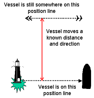 transferred position line. You can do this when there is only one navigation mark available at a time. Although this technique can be used at any time, the limitations of accuracy and the amount of work involved will probably mean that it is easier to take a 3-point fix.
Ideally you would use this technique when there is only one object to take a bearing from, a situation which might arise when approaching the coast at night. However, the two bearings can be taken off different objects, it may be that the first target is no longer visible by the time you need to take the second bearing.
When you take a bearing and draw it on the chart, all you can say with any certainty is that you are on that line somewhere.
If you then sail on for 1 hour in a known direction, you can move the position line forwards by the distance that the vessel has travelled. You are now somewhere on the transferred position line.
At this point all you know is that you are on this line but not how far along it.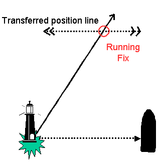
The symbol for a transferred position line is to place two arrows on each end of the line.
Running Fix
If we then take a second bearing (it may be on a different object), we can cross the transferred position line with the second bearing to get a fix.
For this to work, you would also need to allow for any tidal set and drift during the hour.
The sequence to plot a running fix for real is as follows.
- Take the first bearing, note the time and log reading (distance run). Plot this first bearing on the chart.
- Sail for a set time on a steady course, 1 hour is common.
- At the end of the hour take a second bearing, note the time and log reading again.
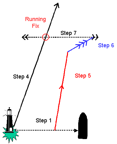
- Plot this second bearing on the chart.
- Chose any point along the first position line, and plot a line to represent the distance and direction the vessel has travelled (the Water Track). You can draw this line from any point on the first bearing because if you chose two different places on the bearing and plotted the water track they would both end on a line that is parallel to the first bearing.
- At the end of this Water Track draw a line that represents the distance and direction that the tide has carried the vessel (the Tidal Vector).
- Crossing the end of the Tidal Vector, plot a line parallel to the first position line, the vessel is now on this line. As it is also on the second position line where the two position lines cross is the vessel's position.
Astro navigation
Whilst not a technique that you will need to use frequently nowadays when sailing in coastal waters, this principal is used in astro navigation for plotting sun sights. When you take a sun sight with a sextant, the line needs to be transferred in the same manner to allow it to be crossed with another sunsight taken at a different time.
For this reason anyone aspiring to take the Yachtmaster Ocean course should be familiar with the technique of plotting a running fix.
Question 1 Chart RYA 3 Variation in 2015 is 6 °W.
1. If a navigator sees the St Anthony's Head Lighthouse (46° 13.9’N 06° 10.2’W) on a bearing of 050°M, then one hour later it bears 125 °M, what is the latitude and longitude if the course was 330 °M and the vessel travelled 5.1M, during a period when the current was 343°T at 1.2kn?
Question 2 (Yachtmaster level question)
2. August 22. Chart 2. Variation = 7°W.
| Time | Comments | Course | Log | Wind | Leeway | Baro |
| 0758 | Skerries Point LtHo (50°14.47’N04°29.80’W) bears 335°M | 299°C | 56.0 | SW5 | 5° | 1030 |
| 0858 | Skerries Point LtHo bears 062°M | 299°C | 60.0 | SW5 | 5° | 1030 |
Diamond G. Plot the fix at 0858.
Additional Resources: