

Navigation and Chart work - Tidal levels
Tidal levels on charts
At the bottom of chart 3 there is a Tidal Levels table, most charts will have something similar. This table records the levels of HAT, MHWS, MHWN, MLWN and MLWS at important points on the chart. This table was explained earlier.
The information from these tables allows us to make a guess as to whether it is possible to pass over a bank or under a bridge at the times of spring or neaps.
Using Chart 3.
What is the depth of water at high water, over a bank that dries 3.0m at Victoria?
MHWS Victoria 5.6m
- Bank dries 3.0m
Depth 2.6m
What is the depth over the same bank at MHWN?
MHWN Victoria 4.4m
- Bank dries 3.0m
Depth 1.4m
Very quickly you can see that you may be able to cross this bank at springs, but in most vessels it would not be advisable at neaps. With this table at least you can make a decision as to whether it is worth working the heights out more accurately.
This can be very useful in some of the Brittany ports; some can be entered at springs. Then, over the next few days the level of high tide drops off enough that you can not leave. You may end up being stuck until the next spring tide! This is known as being Neaped.
Question 1.
Chart 3. What is the depth of water at MLWN over a bank which has a drying height of 1.2m, at Victoria?
Question 2.
Chart 3. What is the depth of water at MHWN in a channel with a charted depth of 1.0m at Dunbarton?
These were two simple tidal height calculations but even with these it is worth creating a diagram with the relevant figures included. This should help differentiate between situations where the seabed is above and below the level of chart datum.
Air draught
The height of a vessel is known as its air draught. If you plan to pass under a bridge or electric cable you will need to know your air draught and how to calculate if you will clear the obstruction.
On Chart 4, In the south west corner of chart 4F, find the cable between Synka and Hera Islands. Next to the cable there is a symbol that indicated the safe clearance of the cable over the datum level in use for this chart. In this case it is 18m above H.A.T. We always used to teach that overhead clearances of bridges or cables was above M.H.W.S. this has recently changed to being above H.A.T.
If your boat has a mast height of 15.0m, what will be the clearance at MHWS? (Use Dunbarton as the nearest).
HAT Dunbarton 4.6m
MHWS Dunbarton -4.2m
MHWS Tide level below HAT 0.4m
Wire height above HAT +18.0m
Wire height above the water 18.4m
Mast height above water -15.0m
Clearance 3.4m
It is a good idea with any tidal height situation to draw out as much of the 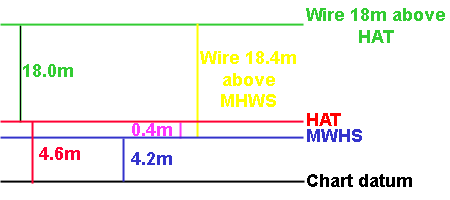 information as you can to create a picture. Often once the figures you know are in place it becomes obvious what you need to calculate.
A clearance of 3.4m should be enough, remember there may be aerials on top of the mast as well. Note that the clearance is this case is the safe clearance not the physical clearance below the wire. Passing below a high voltage cable with a metal mast could be dangerous if this limit is not respected.
Whenever you pass under a bridge, it always seems very close to your mast because of the perspective of looking up at it, even when you have worked the heights out; it can still be a scary experience passing under a bridge for the first time. On a couple of occasions I have had a nervous helm throw the boat's engine into reverse at the last moment because they though we were going to strike the bridge with the mast, only to realise that the bridge was about twice the height of the mast.
Tidal levels table in theTraining Almanac
On page 12 of the Training Almanac there is a table of tidal levels at the standard ports and also for secondary ports. This table includes the data from the tidal levels table on the chart but also for many other places on the charts.
Question 3.
Use this table to answer the next question.
Chart 4C. What is the clearance under the bridge at leading to Blackmill Marina at MHWN? (Use Blackmill)
The twelfths rule
This is a short cut to working out the height of the tide, which can be useful. It works on the principle that the tide rises or falls to a regular pattern and is effective in areas where the tidal curve is smooth and preferably where the periods between high and low tide are 6 hours.
A good example that fulfils these criteria is Victoria on page 36 of the Training Almanac; a port where it would not work well is Portsmouth if you can obtain a copy of a real almanac that covers the south coast of the UK.
To use the rule you need to find a twelfth of the range of the tide, then apply it as follows.
HW 1200 5.2m
LW 1800 0.4m
Range = 4.8m, therefore 1/12 is 0.4m.
The tide would fall to the following pattern:
1200 5.2m
1300 -1/12 of range -0.4m = 4.8m
1400 -2/12s of range -0.8m = 4.0m
1500 -3/12s of range -1.2m = 2.8m
1600 -3/12s of range -1.2m = 1.6m
1700 -2/12s of range -0.8m = 0.8m
1800 -1/12 of range -0.4m = 0.4m
This can be a very useful quick method of estimating the height of the tide; it is not very accurate in the Solent due to the unusual pattern of the tides. The figures in this example are also artificially convenient and they rarely fit so neatly.
Additional Resources: