

Navigation and Chart work - Bearings
Three Figure Bearings
A position can also be given as a bearing and a distance from a 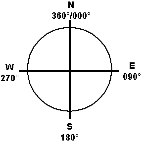 known point.
A bearing is a direction, expressed as a three-figure number. Bearings are measured clockwise from north.
Bearings are always given as three figures because if you only wrote down 35°, it could easily be mistaken for 350°.
On longer passages when it is necessary to run a watch keeping system, it is not unusual for there to be several navigators. For this reason there are standard ways that certain navigation processes are performed.
Direction can also be described by Quadrantal Notation; that is North, South, East and West. Old compasses were marked in this style, but it is obviously not accurate enough for navigational purposes.
Quadrantal bearings
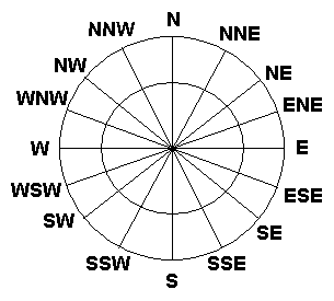
Most people are familiar with the basic quadrantal bearings, but we can break the 360° down to 32 points. A point is 111/4°. 1 point west of south is normally written as S/W and the point between ESE and SE is SE/E and so on.
Normally the only time that you will deal with quadrantal notation is with the wind directions given in shipping forecasts.
On Chart 3. Draw a pencil line between the lighthouse at S. Anthony's Head (46° 13.9'N 06° 10.1'W) and the light on Steven's Rock (46° 03.4'N 06° 18.8'W).
Lay your plotter on the chart, so that one side is along this line. Make sure that the direction of bearing arrow is pointing towards Stevens Rock.
Rotate the compass, until the north mark is to the top of the chart.
Then line up one of the horizontal or vertical lines on the compass rose with a line of latitude or longitude, you may need to slide the plotter along the pencil line, until there is a suitable line under the compass rose of the plotter.
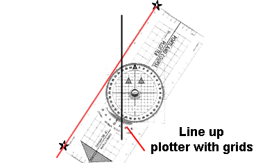
Then read off the bearing, at the marker on the body of the plotter.
The bearing should be 210°. This is a true bearing, because it has been measured relative to True North. A true bearing would be written-092°T.
Later on you will be using bearing other than true ones, it is important that they are correctly marked.
Now turn the plotter, so the direction arrow is pointing from the rock, to the lighthouse, and check the bearing in that direction.
It should be 030 °T.
That is the reciprocal bearing; of course, you could have just subtracted 180° from the original bearing!
An easy mistake to make with the plotter is to place the compass rose 90° or 180° out of line, or to have the plotter itself pointing in the wrong direction. With practice you will learn to spot when you have done this, because you can compare the bearing with the approximate quadrantal bearing. E.g;
A bearing of 210° is about Southwest, so the plotter should be pointing Southwest.
To plot a bearing on the chart is very similar.
Find the light at Stevens Rock again.
Turn the protractor until 146°T is set on the direction of bearing line.
Lay the plotter on the chart with one edge touching the light.
Swing the plotter round until the north mark is to the north and the grids on the compass rose line up with the grid on the chart.
Draw a line from the buoy in the direction of the arrow on the plotter.
This line should pass through the flagstaff at the Coast Guard station on Cape Donne.
Questions.
What are the bearings from the points that were plotted on chart 4 in the following order?
1) 1 to 2.
2) 2 to 3.
3) 3 to 4.
4) 4 to 1.
Additional Resources: