

Navigation and Chart work - Distance
Distance
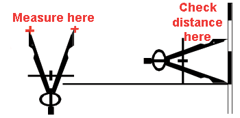
Distance is measured on the latitude scale, at the sides of the chart.
One minute of latitude is one nautical mile-at that latitude.
One nautical mile is 1852 metres.
One minute is one nautical mile (M) at that latitude because on Mercator Projection charts the latitude scale increases the further north you travel.
In fact, the Earth is not a perfect sphere, so that the length of a nautical mile varies from place to place. By international convention it is standardised at 1852 metres.
A distance that is used in conversation is a Cable; a cable is 1/10 of a nautical mile. So you could say you were 3 cables from a buoy, as a means of describing your position. As a rough approximation a cable is about 200 metres (m). It is notoriously difficult to estimate distances at sea by eye, but multiples of 200m are not to hard to guess.
Distances are measured with the dividers, and then transferred to the latitude scale to be converted into miles.
Measure the distance from the Steven's Rock light to the flag staff at the Coast Guard station along the bearing that was plotted in the bearing section.
It should be 3.5M.
Writing a capital M after the distance signifies nautical miles. A lower case m is used to signify metres.
Describing a position
In a situation where we need to give our position, such as if we were in distress. We can describe our position either as a Latitude and Longitude or as a bearing and distance from a known point.
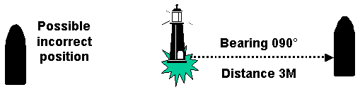
In the latter case, the standard convention is for the bearing to be from the known point. This avoids the ambiguous situation that may occur if the point of reference has water on all sides.
Speed
Speed is expressed as Knots. 1 knot is 1 nautical mile per hour. A speed of 5 miles/hour would be called 5 knots. Not 5 knots/hour.
Exercises
Go back to the points you marked on the chart for for the positions exercise
and measure the distances between the following
points. Make sure that you are measuring in the correct direction!
1. 1 to 2.
2. 2 to 3.
3. 3 to 4.
4. 4 to 1.
On chart 3 plot the following positions and find the meanings of the symbol. Some of them are on the land!
5. 026 °T 3.73M from Christopher Point Light House. (45° 53.9'N 05° 47.0'W)
6. 155°T 3.06M from Christopher Point Light House.
7. 207°T 5.49M from Christopher Point Light House.
8. 308 °T 7.26M from Christopher Point Light House.
Bearing and distance to a waypoint at a compass rose
Positions may be given as a bearing and distance to a waypoint. If a waypoint is plotted at the small dot at the centre of a compass rose is can be very easy to plot the vessel's position on a chart.
What is the latitude and longitude of the following points? What does the symbol at each position indicate? The bearings and distances given are towards the dot at the centre of the compass rose on chart 3 at 45° 53.9'N 05° 55.3'W
8) 181°T 6.13M
9) 110°T 5.17M
Additional Resources: