

Navigation and Chart work - Chart projections
Projection: Mercator.
Mercator projection is the method by which the curved surface of the 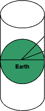 Earth has been drawn on a flat sheet of paper. There are other projections, which you will come across, in most cases they will have little effect on the way you use the chart.
If you imagine a cylindrical screen around the Earth. Then project a line from the Earth's center, through its surface on to the screen so that the features on the surface are projected on to the screen. When this screen is opened up and rolled out flat you have the chart that we use to navigate on.
This will give you an idea of how Mercator Projection works.
With any chart projection there is some distortion created, the major consequence of Mercator projection is that the further north you travel, the divisions for latitude on the chart will become longer. This is of little practical consequence unless you are planning passages greater than 600 miles in length.
To demonstrate this, measure the distance between the 5' and 10' marks on the bottom right hand side of Chart 1. Now go to the top right hand side of the chart and compare this distance with the 5' between 20' and 25'.
There should be a slight difference. That is the effect of Mercator projection. We use the latitude scale (the one on the sides of the chart) to measure distance, because 1' of latitude is the same as 1 nautical mile at that latitude. As a result, when you measure the distance between two points on the chart, you should always go to the side of the chart at the same latitude to measure the distance.
Another common projection used on navigation charts is the Gnomonic Projection.
For a Gnomonic Projection, imagine placing a screen tangential to the Earth's surface and then project the features onto it (obviously this is done mathematically). This projection can be used in polar regions where a conventional Mercator Projection would not work, it is also used for large scale harbour plans and charts for planning ocean crossings.
Mercator |
Gnomonic |
|
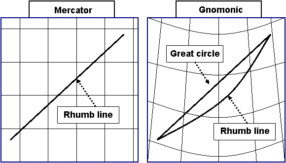
On a mercator projection chart, lines of latitude are parallel as are lines of longitude. A rhumb line course of 040° crosses each meridian (lines of longitude) at the same angle. A rhumb line course is used in all coastal navigation. If a passage is over 600 miles it may be quicker to sail a great circle route, in practice this not always practical as winds, currents and weather systems all influence the choice of the best route. |
On gnomonic projection charts, meridians converge and lines of latitude are curved. Great circle routes are straight lines and rhumb lines are curved. A great circle is the longest line that can be drawn around the earth. A segment of a great circle is the shortest distance between two points on the earth surface. When planning ocean passages, small scale gmomonic charts can be used to calculate great circle routes. On longer passages, ships can save fuel by sailing the shorter great circle route. |
Additional Resources: