

Navigation and Chart work - Tidal heights
What is the height of the tide at a specific time?
So far we have only looked at the tabulated tidal information on the heights of the tide. This is fine if all we wish to know is the height if high and low water, but often you will need to know the height of the tide at other times of the day.
Turn to page 36 of the Training Almanac.
The curve that is drawn there represents the tide rising from low water to high water, then falling back down to low water, the passage of time is noted at the bottom.
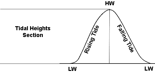
At the bottom of the curve there are times before and after HW, so now you can see that at Victoria the tide rises for nearly 6 hours and falls for just over 6. If you can obtain a real almanac for the UK compare this to the curves for Portsmouth and Dover, from these you will see that the tide does not always take 6 hours to rise and fall.
The small divisions on the time scale are normally to 10 minutes intervals, by guessing between these points it is fairly easy to work to 5 minutes accuracy.
The tidal curve for each standard port is very different in shape. You can see that the curve is not always even. There may be steep parts and flatter sections. Where there are two curves, a dotted one and a continuous one, these represent the pattern of the tide on neap and spring tides respectively. From the tidal range box you can see that the dotted line is for a neap tide.
If the range of the tide in question is not a spring or neap range, you can interpolate between the two lines by eye.
Standard Ports
For the tidal stream information we always worked with the data for Victoria. Tidal heights are different; we need to use the information for the nearest port that is tabulated.
Around the coast are standard ports, these are harbours for which tide tables have been calculated, most are major commercial ports but not all.
To start with, the questions we will do will all be based on standard ports, you must find the tide table for the port in question, there is an index at the front of the Training Almanac.
Turn back to pages 35 and 36 of the Training Almanac.
We are going to find the height of tide at 1137UT on 3rd December at Victoria.
To use the curve you will need to know the times and heights of high and low water for the day in question.
I suggest that you lay your work out as follows:
December 3rd Victoria UT
HW 0907 5.7
LW 1510 0.8
Range = 4.9m therefore a spring tide.
1137 is HW + 2 hours 30 minutes.
The nearest high water to 1137 is 0907. Write 0907 in pencil in the box below HW on the diagram on page 36.
In the box for HW+1 enter 1007, and 1107 then 1207 in the HW+2 and HW+3 boxes respectively.
To enter the heights of the high and low water in the left hand side of the diagram, draw a sloping line from 0.8m on the bottom LW line up to 5.7m on the top HW line.
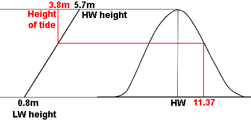
Back on the time part of the diagram, follow the line up from where you wrote 1137, until it cuts the tidal curve (we use the solid line, because this is a spring tide). Then using a plotter or ruler, draw a line left until you reach the sloping line you drew between the levels of high and low water. Then draw a line from that point up or down to the depth scale. You should have a depth of 3.8m.
Height of tide at 1137 is = 3.8m.
What we have just done will be a small part of a bigger problem, so get in to the habit of laying the workings out tidily and labelling each number as you go, if you do not you will become very confused about what the numbers mean.
Can you now find the height of the tide at 1915UT on December 3rd?
First, the diagonal line we drew earlier must be erased. The new line must be drawn between a low water height of 0.8m and a high water height of 5.9m. This is because these two levels are the heights of the tides on either side of the time in question (High Water is now 2125UT).
This is an important point later, when you are working with questions which involve finding the tide height at two different times.
Write in the times before HW. 1915 is HW-2 hours 10 minutes.
It is possible to be accurate to about 5 minutes with these curves. Remember, this is very different to when we found the tidal stream information, which covered an hour. With tidal heights we are working to the nearest minute!
Go through the same process as before to find the height of the tide at 1915.
The height of the tide at 1008 is 4.65m. Normally rounded up or down to 4.6m or 4.7m, there is little point in working to two decimal places for tidal heights.
Remember that if the tide is a sping tide use the solid part of the curve, if it a neap tide use the dotted part and it the range of the tide is mid way, interpolate (guess) between them.
Question 1.
What is the height of the tide at Namley Harbour on 6th September at 0941 Summer Time?
Question 2.
What is the height of the tide at Colville on the 7th October at 0329 in Summer Time?
Question 3.
What is the height of the tide at Port Fitzroy on the 15th June at 1246 in Summer Time?
What is the time when the tide reaches a required height?
By this method you can find the height of the tide at any time of day, but sometimes we need to know when the tide will reach a certain height.
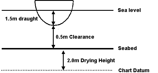
An example would be when there is a sandbank or bar that you need to cross to enter a harbour (like Salcombe). If the bar you need to cross has a drying height above chart datum of 2.0m. Your boat has a draught of 1.5m, but you wish to have a clearance below the keel of 0.5m, you need a height of tide of:
2.0m Drying height
1.5m Draught
0.5m Clearance
4.0m minimum height of tide required.
With this type of question it is worth drawing out the information, some situations will be much harder to work out than this one.
Follow the working for the next example.
When will the height of the tide fall to 3.0m at Hamilton Sound on the afternoon of 9th August?
9 August Hamilton Sound Summer Time
HW 1357 5.8
LW 2016 0.5
Range = 5.3m therefore a spring tide.
The tide will fall to 3.0m at HW+ 2 hours 50 minutes 1647 Summer Time.
Question 4.
When will the height of the tide rise to 2.0m at Port Fraser on the afternoon of 14th October?
Remember to draw out the information in the following questions, it will help you to see what it is you are trying to find out.
Question 5.
What is the earliest, on a rising tide, that a boat with a draught of 1.3m can cross a bank with a drying height of 0.8m with a clearance of 1.0m, at Colville on the afternoon of 14th October?
Question 6.
A boat with a draught of 1.4m is in a creek in Namley Harbour which dries 0.9m above chart datum. What is the earliest on a rising tide that she can depart with a clearance of 0.5m on a rising tide the 25th May?
Question 7.
A boat with a draught of 1.5m wishes to use a channel at Port Fitzroy with a charted depth of 0.4m, on the morning of 28th December. What is the earliest on a rising tide that there will be a clearance of 1.0m?
Additional Resources: