

Navigation and Chart work - Chart Corrections
Chart corrections
Features shown on charts change, either because they are man made, or due to natural changes. Therefore, it is essential that our charts are corrected, or updated regularly.
The Hydrographic Office issue Notices to Mariners (NTMs) each week which cover all the changes, in all their publications world-wide. As there are thousands of charts and books on this list, it can be a bit cumbersome for a small boat skipper. In addition, they publish Notices to Mariners weekly on their website www.ukho.gov.uk . Obviously the latter are easier for most yachtsmen to use.
Another source is yachting magazines. They publish the more important changes and focus on those relevant to small craft.
Harbour authorities also publish details of changes for which they are responsible. Some have websites; most have a notice board where you can find copies.
To correct a chart, look up the number of the chart in the index at the front of the NTM, by the chart number there will be a list of all the corrections that relate to that chart. Each correction is given a number to identify it.
You then need to look up the correction to discover the details.
It may be simple, larger corrections are carried out by sticking a new section of chart to the original, in this case you just need to line the insert up correctly.
If a feature needs deleting, you just draw two fine lines through it and any associated writing. If a feature has been added, you will need to draw in the symbol as neatly as possible.
Special correcting pens are available, often in a pack with a stencil to help you draw in the symbols. At least you will need a very fine, waterproof pen.
After making the correction, you then need to write the number of the correction in the bottom left corner of the chart. This has been done on Chart 4.
Find the legend: Notices to Mariners 2006-8703-8812-9040 The last correction for this chart was the 9040th correction issued for all Hydrographic Office Publications in 2006.
This is so that anyone looking at this chart can tell if it is up to date. The last line of a chart correction gives the number of the previous correction on that chart, if this is not the last number that is written in the bottom left corner, a correction has been missed.
A chart, which is not up to date, is dangerous, as there may be new hazards, or more commonly, navigation aids may have been changed. This can make navigation especially difficult at night. Always correct your charts!
In pencil, correct Chart 3.
2842 NEW TERRITORIES, South coast - Beaufort Bay-Wreck
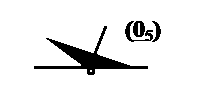 Insert 46° 25.14'N 005° 54.77'W
Chart [Last correction] - 154 [2380/99] - Training Chart 3 [9040/06] Trinity House (HH232/420/06)
Do not forget to note the correction number down on the end of the list in the bottom left corner.
Additional Resources: